Thursday, October 22, 2009

Algonquin, Wright Mountains: Winter Wonderland (10/14/09)


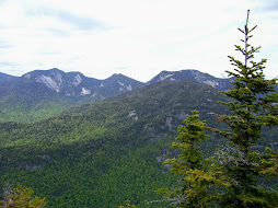
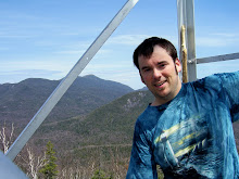
This was another hike that I organized through a local hiking group, so there ended up being seven of us that went on this hike. As I kept track of the weather, as hike date approached I knew there would be a very good chance of having some snow and ice on the tops of the mountain, so when we actually saw some it wasn't really a surprise. What was a surprise was how low an elevation that the snow stuck and how much was on the tops. The trees were frosty white that morning I would say as low as 3000' and the last two thirds of the trail was in snow and ice. We were thankfully prepared and brought our traction control, for me a chance to really test my micro-spikes out. After the trip as a whole, climbing up and down solid sheets of ice, hopping from snow covered rock to rock, and wading through drifts several times up to my knees I give the micro-spikes a solid two thumbs up! Our goal going into the hike was to do Algonquin, Wright and Iroquois. Unfortunately, due to the pace of the group as a whole, the weather conditions and temps and energy levels we stopped after only doing Wright and Algonquin. I'll just have to go back and do Algonquin and Iroquois another day, which isn't all that bad since we were in the clouds on top of both mountain and had zero visibility. The overall trail wasn't extremely long, but the last pushes up both Wright and Algonquin had their share of very steep pitches, both rock slab scrambles and rock hopping. It was definitely a neat experience doing it when everything was covered in snow and ice. It gives everything a different look. Having some sort of traction was a must. It was interesting to see the change in temperature the higher you went, in the trail became more solid and no running water. We had a quick lunch on the shoulder of Wright Mt before heading back down and up Algonquin. Even being mid week and very wintery, we did encounter at least 4 or 5 parties who were also doing the hike that day. Once we got to the summit of Algonquin, we snagged a few quick photos and decided not to pursue Iroquois today. The trip back always seems to be longer than the way up, I'm sure due to several factors. Anyway, we all made it back to the Loj without any complications and I bagged #16 & 17 for this year.

Saturday, October 10, 2009

Giant & Rocky Ridge Peak 9/30/09

There was a low percent chance of rain for the day and when we started the hike the temps were in the high 30's, so we really weren't sure what to expect on this hike. I had been wanting to do this hike for a while now, but had determined to hold off and do it in the peak of leaf season as it has been described as possibly the best fall foliage hike in the high peaks. I ended up doing the hike with four others from a hiking group I am apart of. I decided to do the hike out of the Rt 9 trail head, up over Blueberry Cobbles, Bald Peak, Rocky Ridge Peak, and lastly Giant. The trail to the top of Giant is eight miles and a huge 5300' ascension! Since we had enough people to spot cars we decided to do that to cut down on the mileage. By the time we actually got hiking it was 9am. The weather was mostly cloudy but no precipitation and the colors were still in pretty close to peak season. The hike up from the Rt9 trail head has many vistas and exposed rocky ridge lines that offer many great views. We kept a steady pace for most of the way up, with lots of photo breaks, so by the time we completed the hike and got down to the car at the base of the Ridge trail it was close to 6:15pm. As it was close to noon when we reached the summit of Bald Peak, we decided to stop and have lunch there. Oh, one thing that seems to stand out about this hike from a wildlife standpoint was the number of grouse we jumped. I believe over the course of our ascent we jumped at least 6 grouse! And, just before the summit of Bald Peak we came across a very chatty bird who I mimicked in conversation for several minutes. He must have been very welcoming of the conversation, lol. The trail was really quite dry over almost the entire stretch of the trek with the small exception being around Lake Mary-Louis and the small water crossing there. As we approached the summit of Rocky Ridge we crossed over some really cool alpine meadows which added a nice variety to the course of the hike. As we got close to the summit of Rocky Ridge we climbed into a snow squall, the first snow of the year! As it turned out, we were in snow on the summit of both high peaks today; the trees and grass held the snow, but the ground itself was still to warm to hold it. We stopped briefly on top of Rocky Peak for photos, but the wind was very strong and with the temps made it too cold to stay there for any longer. The descent into the col between RRP and Giant was quite easy; it was the ascent up the east side of Giant that was by far the steepest and roughest on the hike today. Even still it went by with no problems and we made it to the top of Giant with no issues. Unfortunately we were in a snow cloud so we had close to zero visibility on the top of Giant. Oh well. The last three miles down Giant were definitely the most unpleasant for me. All three are steep and rough with no breaks in the loss of elevation. As it is, I would rather climb steep than descent it. My knees don't care for it too much, heh. Anyway over all we all had a great time, on one of the toughest hikes yet. Two more bite the dust! #14,15 of this year.

Friday, September 18, 2009

Mt Marshall (9/16/09)

#13 this year, #16 total.
It was a nice fall day for a hike. I headed out with my friend Rob for the Upper Works trail head at 8:30am and we were on the trail by 10:45am. The weather was nice for hiking, not as warm or sunny as other days, but maybe 55-60F for most of the hike and a mostly cloudy (but no rain) day. When I was planning the trip I didn't really count the miles carefully and was under the assumption that it would be close to 10 miles round trip. In actuality it was around 14 miles and ended up taking us a little longer than originally thought. The trail back to the Flowed Lands/Calamity Pond was very nice. There was some elevation gain but nothing more than moderate and the trail was very well established and maintained, with some really beautiful scenery along the way. Several spots we saw the beginning of the turning of the fall colors. We took a short stop to check out the David Henderson monument, at the site where he accidentally shot and killed himself back in 1845. As we approached the Flowed Lands lean-to, I got my first foot soaker of the year when I was rock hopping over some muddy water and my right foot slipped and sunk over the top of my boot. My foot got a bit wet, but not squishy wet so I didn't change out my socks on the spot. When we got the the Flowed Lands area we took a few minutes to enjoy the awesome view! It truly is a gorgeous area. From there up to the break off point up to Marshall the trail went quick. The trail up Mt Marshall is deemed trailess, but the herd path up is well defined and marked where needed so we had no problems finding our way. For the first two thirds of the trail, the path follows a stream bed up. I have heard that Marshall is known for its moss and I definitely can see why after climbing it. I have never seen so much lush, dense moss as there is along the trail up. It is like a carpet of soft, fuzzy green everywhere! We had a couple steep pitches up the second half of the Marshall trail, and the last quarter of a mile had a few rock scrambles that were needed to navigate up. Once we made it too the top, it was PB&J time and I finally got out of the wet socks! Off a short side trail we had some really nice views of Marcy, Skylight, Redfield, Allen, Cliff and the Santinoni Range. On the way back down, we enjoyed several great views of Iroquois Mt. We picked our pace up a bit on the way back down in an effort to make it out before darkness set in, and we only ended up doing the last .25 mile or so in the dark. Overall the trip took us close to 8.5 hours. It was a great time, with some super views. Another one bites the dust!

Monday, September 14, 2009

Sawteeth, tail of two trails (9/2/09)


A beautiful day for a hike! Sunny, low humidity, and temps in the 60's... I had hiked Sawteeth a number of years ago with my dad, doing an up and back on the Scenic trail, but as it turned out didn't quite make it to the top of the actual summit, just the shorter of the two. I decided this time to make a loop of it, going up the Gothics trail, and down the Scenic trail. First time in a while I had to do the entire length of the Lake road, but at least it goes by fast. The trek up on the Gothics trail was pretty straight forward. Shortly into the hike, a great view of Rainbow Falls is available. It is really a sweet view. The rest of the way up to the col and the split in the trail between Sawteeth and Pyramid wasn't too bad; a steep stretch here and there but nothing to demanding. After taking the turn up to the summit of Sawteeth one needs to climb through a crevasse in the rock, but its surface is rough enough that footing isn't too difficult as long as you pay attention. The view from the top of Sawteeth towards the Great Range is fantastic! You get a great up close and personal view of Pyramid, Saddleback and Basin, along with views of Armstrong, Haystack and Marcy. After munching down my PB&J sandwich I continued down the col between the two summits of Sawteeth. It was by far the muddiest part of the trip, which one would expect of cols. Maybe because it had been so long ago that I had climbed Sawteeth via the Scenic trail I had forgotten how absolutely rough and rugged it is! Out of all the trails I have hiked so far, I definitely feel confidant saying it is the most rugged trail I've hiked! Ever step for pretty much the entire length of the trail requires careful thought and effort, whether do to steepness, ruggedness or even the flat spots were across the face of the mountain that requires uneven footing. Even when I had completed all of the decent and arrived at the lake, the trail was nothing but boulder and tree navigation. I know that many times the hike up a mountain takes longer than the decent, but in this case due to the different difficulty of trails, it was exactly the opposite. The Scenic trail does offer some amazing views towards Dix, Nippletop, Dial, Colvin and Blake mountains along with the Lower Ausable lake, Fishhawk cliffs and Indian Head so all the work isn't for nothing. I was happy because even though the decent took allot out of me, especially my feet, I had enough energy to jog my way back down the Lake road to the check out. Another high peak of the list! #12

Monday, August 31, 2009

Dial, Nippletop #10/11 (8/27/09)

I was going to try to go hiking yesterday, Wednesday, but the forecast for yesterday was 40% chance of thunderstorms and for today was mid 60's and blue sky. Thankfully I was able to switch shifts at work to make it out today, because as far hiking weather goes it didn't get any better than what I had for today. It was absolutely perfect! I started out of the Ausable Club and decided on doing the loop, rather than up and back. The hike over the shoulder of Noonmark was pretty neat, as the forest was regrowing from the fire 10 years before. The top was covered in new growth and some remaining dead tree trunks from the fire. There was alot of bird activity as I made my way over towards the col between Noonmark and Bear Den Mtn.
After stopping for a quick drink, Clif Bar, a chat with another hiker named Bruce, and a few pics towards the Great range and Dix Mountain, I continued on towards Bear Den. The decent into the col wasn't nearly as bad as the ADK book had described it. They had mentioned two "very steep" descents, but also mentioned that at the time of the publishing several years ago the trail hadn't recovered from the fire fully and that when it did that the trail would revert to the older path that was less steep, so maybe that was the case. The climb up Bear Den had a steep stretch or two but nothing remarkable and the view from the top was non-existent. From there the trail made its way up towards Dial Mtn. The trail was very nice and maintained and instead of any steep stretches it was really just a long steady climb. Once I reached the summit of Dial, I was rewarded with a beautiful view of the Great range and more. I could see Lower, Upper Wolfjaw, Armstrong, Gothics, Sawteeth, Basin, Big Slide and more. Being in no hurry, I took time to have a sandwich and enjoy the view and awesome weather. After a few more pictures, it was time to head off for the tallest mountain of the day, Nippletop. The trail was really quite dry all the way up to the last stretch of Nippletop. The last .2 of a mile or so had some muddy patches but not that bad. The view from Nippletop was amazing! It had all the same that were visible from Dial and many more, including Dix, Macomb, Allen, Skylight, Haystack, Marcy, Algonquin and Saddleback. I kicked off the boots an relaxed on the rock for probably close to half an hour and chowed down another Clif bar. I am totally sold on those things! Several more pictures and a last glance around at possibly my favorite view yet in the Adirondacks and it was off, down the Elks pass trail. For everything that the trail up had lacked in steepness, ruggedness and mud, Elks pass was quick to make up. Not that it was extremely steep, but it was steep and it stayed that way for almost the entire portion of the 2 mile journey to the intersection of the trail up Colvin. The portion of the trail around the two ponds at the base of the decent also had some of the thickest, deepest mud i've seen yet this year. It was real watery, puddle type mud, but more thick, pasty mud. After what seemed like longer than it should have been I finally intersected the Colvin train and continued my trek back to the Lake road. Once there I made awesome time. Whether it was from the Clif bar or something else, I had a high level of energy even after more than 11 miles completed so far, so I jogged the entire length of the road back to the sign in log. I had the neat experience of jumping 3 deer along the side of the road on the way back. Overall I would tentatively rate this my favorite hike yet! Two more down, more to go!

Thursday, August 6, 2009

Lower Wolf Jaw #9

8/05/09
Another beautiful Wednesday to go hiking! I started out of the Ausable club and took the White trail to do the trip as a loop. I don't think this trail is used as much as the other, as the distance is a bit longer and there are no other high peaks off of it. That said it was still in great condition and had some really beautiful views on the way up, namely of Giant Mountain several times, and of Dix, Noonmark, Dial, Nippletop, Colvin and Blake. The trail had several steeper areas but overall I would say nothing too threatening until you approached the col that leads up to LWJ. On the last pitch up to the summit of LWJ there is a 50 yard stretch or so that is as steep as I've seen so far, and requires some hand and feet scrambling and some concentration to avoid some nasty things. Nothing really technical though and it went without more than a bump on my head from knocking it against a branch that I didn't spot in time. From there it was up to the top with some really nice views of the Great Range, MacIntyre Range, Marcy, Colden, and Big Slide...albeit through a limited range of vision. The trip back down the col between the Wolf Jaws was steep but nothing too crazy, and the trek down the moutain was pretty constistantly steep for the first mile or so, then was really just a walk in the woods for the rest of the trip back to the checkin. You do get some really nice views of a cascading waterfall and the East branch of the Ausable River as you head back, at least if you take the East River trail like I did. I even had the neet experience of spotting two deer, a doe and a fawn, less than 25 yards away along the side of the road on the way out! Yaah!

Street and Nye, # 7,8 (7/15/09)

A beautiful day to go for a hike. My friend Rob and I decided on doing the tandem trailess mountains of Street and Nye out of the Adirondack Loj. As far as trailess treks that I have done so far this one was pretty straight forward. We had a moderate river crossing towards the beginning but it wasn't that bad; we managed to make it across by rock hopping. The trail up to the split was pretty easy to follow with only one spot that we had to stop and do a couple seconds of recon. Up until the last half mile or so before the split the trail was pretty open and simple. The last bit was more true to what I would expect a trailess to be, trail just wide enough to get through, navigating blowdown, and not seeing where the trail is leading. When we got to the split we were attacked by a swarm of black flies. We took just a minute before heading out to do Nye, which took all of 20-25 minutes to go there and back. Not a view to be had so no point of sticking around. The trail up Street had more climbing and certainly took a little longer than Nye to reach. No view from the actual top of Street, but with a small heard path off to the side we had a beautiful view of the MacIntyre Range. Unfortunately I also experienced the worst black flies of the year on the top so even with bug repellent on we only stayed for maybe 10-15 minutes. It took a little bit longer than expected to complete the hike, but overall was still a moderately easy and enjoyable hike.

Thursday, July 9, 2009

Cascade/Porter #5,6


I've had the pleasure of hiking both these mountains before, but it had been a while and I was looking forward to refreshing the experience and the awesome views from on top. These are two of the most hiked, easiest accessed, and awesomely rewarded views, hike peaks there are. The trail is only 2.4 miles to the top of Cascade from the trailhead, and another 1.4 there and back from the trail split to the summit of Porter. The weather was nice when my dad and I did this on 6/23/09. The temps were in the low 70's and was partly sunny with some hazy clouds hanging around. Black flies were definately out, as you would expect for this time of year in the 'dacks. The trail was wet and muddy in most places but not really anything bad or of hindrence other than the col between the two mountains. A few spots on the way to and back from Porter required some rock hopping and selective stepping to avoid boot high mud. There was a pretty good number of hiking parties on the trail today (a Tuesday), but I guess for these mountains any day could be busy. It was pretty amazing, as we approached the trail split for Porter we crossed a i'm guessing woman in her 80's, and then 5 minutes later a large family with several kids in the 2-3 year old range! Just goes to show that you can enjoy hiking at any age if you prepare and set your mind to it! This is a MUST hike for anyone thinking of getting into the hiking of the high peaks. It is relatively easy and the reward from the views on top are hard to beat!

Allen Mt (big nasty) #4


So, unless you've actually done this hike and or take someone who's done it before word, it really doesn't seem like that big of a deal. It's not the tallest or the most intimidating skyline, and most of the actually distance is quite easy. But, after having done it, I can certainly agree with its nickname "big nasty". The over all mileage is huge, 18 round trip. It is 8 miles to the base, over I think 5 river crossings, and although most of it is relatively flat and easy it still is time consuming and energy spent. Then you get the the fun part. Once you finally see the waterfall you know the real work is about to begin. The last mile is definitely up up and away! From the hikes I've done so far, very possibly the steepest in stretches, with Dix Mt being my reference; but the steepness is just part of the fun. Even though the trail is hiked and reasonably clear, it is still an unmaintained trail and very ruff and rugged. Then there is the red/brown algae... That is what this hike is infamous for. You spend pretty much most of the last mile going up very steeply, through a stream, over ice-like algae, after you have already hiked 8 miles! Oh, and when my friend Rob and I were doing it we had the pleasure of doing it in the rain. :D Well, we did make it to the top and through the rain clouds were able to get some nice views of Marcy, Skylight, Haystack, and Gothics. We had left the Upper works parking lot around 9am, and with a hour plus detour thrown in we reached the summit around 4:45pm. Knowing this we pushed ourselves as much as we could to get off the mountain itself and the trailess section of the hike before darkness hit. We actually managed to make it all the way to the last stream crossing before we had to use our headlamps to finish the trek out. By the time we reached the parking lot it was 10:45pm and 14 hours and 20 miles after we started. I'm so glad to have this one done!! I will say though that the trail up to the base of the mountain might be my favorite trail so far. It's a beautiful stroll through the woods and the trailess part is absolutely beautiful in its solitude!
6/7/09

Thursday, June 18, 2009

high peaks #2 and 3- Colvin and Blake


Let me start off by saying "col" should be a four letter word...


Ok, so I started this hike out of the Ausable Club, on a beautiful Wednesday morning, 6/3/09. There were a few black flies out on the road back but once I got going it wasn't too bad. The trail back was well maintained and pretty easy until you got to the trail split for Nippletop via Elk Pass trail. After that there were some serious steeps in short spurts and a number that required hands and feet scrambling to get over and up rocks. Nothing extremely techincal, just took some time and caution. The top of Colvin isn't that big, but the views are spectacular! The Great Range is right in front of you for viewing pleasure, as is Giant, Nippletop, Haystack, and Marcy. After I left the summit and headed out for Blake is where the real "fun" began. It involves dropping down into a very steep col and of course back up to the summit of Blake and the non-existant view from its top, then turning around and doing the same thing all over again to get back to the trailhead. I certainly wouldn't recommend the Blake portion to anyone who wasn't going after the full 46, unless you just like misery. lol I passed one guy doing the same hike I was that day and caught up with 2 more who had done the Elk pass to Nippletop, on the road heading out. Overall, a fun but tiring 15 mile round trip.

First hike peak- Tabletop


Started off with the idea of doing Tabletop and Phelps, but got a later start then I wanted and do to conditions decided to only do Tabletop. Started out from the Loj and trail conditions were great, not much mud and smooth cruising. Trail was pretty much cake till after the Phelps trail split; after that it started to get steeper but nothing too bad, certainly by high peaks standards. After I crossed the stream for the second time snowspines started to show up, with a pretty much constant presence of them from where the trail breaks off the Marcy trail. Thankfully I had just picked up a pair of microspikes (which worked awesome!) but the real challenge of this hike was due to the fact that the warm weather had been melting the snowspines and as i was following the herdpath to the top of Tabletop i was constantly battling the collapsing spines and falling into the stream runoff. Some spines from top to stream bottom were over 3 feet and I had to really work the footing to limit the chance of injury. The view from the top isn' t really that good; basically just some views over treetops on the way up, but it was nice to get this first high peak out of the way. It was also the first trailess one I had ever done. 10.5 miles round trip with a small detour to the falls.
I've always had the desire, to some degree, to hike all 46 of the "high peaks" in the Adirondack Mts of New York. Going into this year I believe the number that I had summited was in the 10-12 range, but because they have been spread out over the last 15 years or so and I wasn't actually logging them, some of them I have forgotten and thus I determined this past winter to rehike all of them and journal them to make them all "official" and become a certified "46er". As I do each hike I plan to blog it and post pics that I take along the trek.
May the journey begin!

Dave aka scotzman