I was going to try to go hiking yesterday, Wednesday, but the forecast for yesterday was 40% chance of thunderstorms and for today was mid 60's and blue sky. Thankfully I was able to switch shifts at work to make it out today, because as far hiking weather goes it didn't get any better than what I had for today. It was absolutely perfect! I started out of the Ausable Club and decided on doing the loop, rather than up and back. The hike over the shoulder of Noonmark was pretty neat, as the forest was regrowing from the fire 10 years before. The top was covered in new growth and some remaining dead tree trunks from the fire. There was alot of bird activity as I made my way over towards the col between Noonmark and Bear Den Mtn.
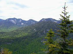
After stopping for a quick drink, Clif Bar, a chat with another hiker named Bruce, and a few pics towards the Great range and Dix Mountain, I continued on towards Bear Den. The decent into the col wasn't nearly as bad as the ADK book had described it. They had mentioned two "very steep" descents, but also mentioned that at the time of the publishing several years ago the trail hadn't recovered from the fire fully and that when it did that the trail would revert to the older path that was less steep, so maybe that was the case. The climb up Bear Den had a steep stretch or two but nothing remarkable and the view from the top was non-existent. From there the trail made its way up towards Dial Mtn. The trail was very nice and maintained and instead of any steep stretches it was really just a long steady climb. Once I reached the summit of Dial, I was rewarded with a beautiful view of the Great range and more. I could see Lower, Upper Wolfjaw, Armstrong, Gothics, Sawteeth, Basin, Big Slide and more. Being in no hurry, I took time to have a sandwich and enjoy the view and awesome weather. After a few more pictures, it was time to head off for the tallest mountain of the day, Nippletop. The trail was really quite dry all the way up to the last stretch of Nippletop. The last .2 of a mile or so had some muddy patches but not that bad. The view from Nippletop was amazing! It had all the same that were visible from Dial and many more, including Dix, Macomb, Allen, Skylight, Haystack, Marcy, Algonquin and Saddleback. I kicked off the boots an relaxed on the rock for probably close to half an hour and chowed down another Clif bar. I am totally sold on those things! Several more pictures and a last glance around at possibly my favorite view yet in the Adirondacks and it was off, down the Elks pass trail. For everything that the trail up had lacked in steepness, ruggedness and mud, Elks pass was quick to make up. Not that it was extremely steep, but it was steep and it stayed that way for almost the entire portion of the 2 mile journey to the intersection of the trail up Colvin. The portion of the trail around the two ponds at the base of the decent also had some of the thickest, deepest mud i've seen yet this year. It was real watery, puddle type mud, but more thick, pasty mud. After what seemed like longer than it should have been I finally intersected the Colvin train and continued my trek back to the Lake road. Once there I made awesome time. Whether it was from the Clif bar or something else, I had a high level of energy even after more than 11 miles completed so far, so I jogged the entire length of the road back to the sign in log. I had the neat experience of jumping 3 deer along the side of the road on the way back. Overall I would tentatively rate this my favorite hike yet! Two more down, more to go!
Monday, August 31, 2009
Thursday, August 6, 2009
Lower Wolf Jaw #9
8/05/09
Another beautiful Wednesday to go hiking! I started out of the Ausable club and took the White trail to do the trip as a loop. I don't think this trail is used as much as the other, as the distance is a bit longer and there are no other high peaks off of it. That said it was still in great condition and had some really beautiful views on the way up, namely of Giant Mountain several times, and of Dix, Noonmark, Dial, Nippletop, Colvin and Blake. The trail had several steeper areas but overall I would say nothing too threatening until you approached the col that leads up to LWJ. On the last pitch up to the summit of LWJ there is a 50 yard stretch or so that is as steep as I've seen so far, and requires some hand and feet scrambling and some concentration to avoid some nasty things. Nothing really technical though and it went without more than a bump on my head from knocking it against a branch that I didn't spot in time. From there it was up to the top with some really nice views of the Great Range, MacIntyre Range, Marcy, Colden, and Big Slide...albeit through a limited range of vision. The trip back down the col between the Wolf Jaws was steep but nothing too crazy, and the trek down the moutain was pretty constistantly steep for the first mile or so, then was really just a walk in the woods for the rest of the trip back to the checkin. You do get some really nice views of a cascading waterfall and the East branch of the Ausable River as you head back, at least if you take the East River trail like I did. I even had the neet experience of spotting two deer, a doe and a fawn, less than 25 yards away along the side of the road on the way out! Yaah!
Another beautiful Wednesday to go hiking! I started out of the Ausable club and took the White trail to do the trip as a loop. I don't think this trail is used as much as the other, as the distance is a bit longer and there are no other high peaks off of it. That said it was still in great condition and had some really beautiful views on the way up, namely of Giant Mountain several times, and of Dix, Noonmark, Dial, Nippletop, Colvin and Blake. The trail had several steeper areas but overall I would say nothing too threatening until you approached the col that leads up to LWJ. On the last pitch up to the summit of LWJ there is a 50 yard stretch or so that is as steep as I've seen so far, and requires some hand and feet scrambling and some concentration to avoid some nasty things. Nothing really technical though and it went without more than a bump on my head from knocking it against a branch that I didn't spot in time. From there it was up to the top with some really nice views of the Great Range, MacIntyre Range, Marcy, Colden, and Big Slide...albeit through a limited range of vision. The trip back down the col between the Wolf Jaws was steep but nothing too crazy, and the trek down the moutain was pretty constistantly steep for the first mile or so, then was really just a walk in the woods for the rest of the trip back to the checkin. You do get some really nice views of a cascading waterfall and the East branch of the Ausable River as you head back, at least if you take the East River trail like I did. I even had the neet experience of spotting two deer, a doe and a fawn, less than 25 yards away along the side of the road on the way out! Yaah!
Street and Nye, # 7,8 (7/15/09)
A beautiful day to go for a hike. My friend Rob and I decided on doing the tandem trailess mountains of Street and Nye out of the Adirondack Loj. As far as trailess treks that I have done so far this one was pretty straight forward. We had a moderate river crossing towards the beginning but it wasn't that bad; we managed to make it across by rock hopping. The trail up to the split was pretty easy to follow with only one spot that we had to stop and do a couple seconds of recon. Up until the last half mile or so before the split the trail was pretty open and simple. The last bit was more true to what I would expect a trailess to be, trail just wide enough to get through, navigating blowdown, and not seeing where the trail is leading. When we got to the split we were attacked by a swarm of black flies. We took just a minute before heading out to do Nye, which took all of 20-25 minutes to go there and back. Not a view to be had so no point of sticking around. The trail up Street had more climbing and certainly took a little longer than Nye to reach. No view from the actual top of Street, but with a small heard path off to the side we had a beautiful view of the MacIntyre Range. Unfortunately I also experienced the worst black flies of the year on the top so even with bug repellent on we only stayed for maybe 10-15 minutes. It took a little bit longer than expected to complete the hike, but overall was still a moderately easy and enjoyable hike.
Subscribe to:
Posts (Atom)