#13 this year, #16 total.
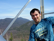
It was a nice fall day for a hike. I headed out with my friend Rob for the Upper Works trail head at 8:30am and we were on the trail by 10:45am. The weather was nice for hiking, not as warm or sunny as other days, but maybe 55-60F for most of the hike and a mostly cloudy (but no rain) day. When I was planning the trip I didn't really count the miles carefully and was under the assumption that it would be close to 10 miles round trip. In actuality it was around 14 miles and ended up taking us a little longer than originally thought. The trail back to the Flowed Lands/Calamity Pond was very nice. There was some elevation gain but nothing more than moderate and the trail was very well established and maintained, with some really beautiful scenery along the way. Several spots we saw the beginning of the turning of the fall colors. We took a short stop to check out the David Henderson monument, at the site where he accidentally shot and killed himself back in 1845. As we approached the Flowed Lands lean-to, I got my first foot soaker of the year when I was rock hopping over some muddy water and my right foot slipped and sunk over the top of my boot. My foot got a bit wet, but not squishy wet so I didn't change out my socks on the spot. When we got the the Flowed Lands area we took a few minutes to enjoy the awesome view! It truly is a gorgeous area. From there up to the break off point up to Marshall the trail went quick. The trail up Mt Marshall is deemed trailess, but the herd path up is well defined and marked where needed so we had no problems finding our way. For the first two thirds of the trail, the path follows a stream bed up. I have heard that Marshall is known for its moss and I definitely can see why after climbing it. I have never seen so much lush, dense moss as there is along the trail up. It is like a carpet of soft, fuzzy green everywhere! We had a couple steep pitches up the second half of the Marshall trail, and the last quarter of a mile had a few rock scrambles that were needed to navigate up. Once we made it too the top, it was PB&J time and I finally got out of the wet socks! Off a short side trail we had some really nice views of Marcy, Skylight, Redfield, Allen, Cliff and the Santinoni Range. On the way back down, we enjoyed several great views of Iroquois Mt. We picked our pace up a bit on the way back down in an effort to make it out before darkness set in, and we only ended up doing the last .25 mile or so in the dark. Overall the trip took us close to 8.5 hours. It was a great time, with some super views. Another one bites the dust!
Friday, September 18, 2009
Monday, September 14, 2009
Sawteeth, tail of two trails (9/2/09)

A beautiful day for a hike! Sunny, low humidity, and temps in the 60's... I had hiked Sawteeth a number of years ago with my dad, doing an up and back on the Scenic trail, but as it turned out didn't quite make it to the top of the actual summit, just the shorter of the two. I decided this time to make a loop of it, going up the Gothics trail, and down the Scenic trail. First time in a while I had to do the entire length of the Lake road, but at least it goes by fast. The trek up on the Gothics trail was pretty straight forward. Shortly into the hike, a great view of Rainbow Falls is available. It is really a sweet view. The rest of the way up to the col and the split in the trail between Sawteeth and Pyramid wasn't too bad; a steep stretch here and there but nothing to demanding. After taking the turn up to the summit of Sawteeth one needs to climb through a crevasse in the rock, but its surface is rough enough that footing isn't too difficult as long as you pay attention. The view from the top of Sawteeth towards the Great Range is fantastic! You get a great up close and personal view of Pyramid, Saddleback and Basin, along with views of Armstrong, Haystack and Marcy. After munching down my PB&J sandwich I continued down the col between the two summits of Sawteeth. It was by far the muddiest part of the trip, which one would expect of cols. Maybe because it had been so long ago that I had climbed Sawteeth via the Scenic trail I had forgotten how absolutely rough and rugged it is! Out of all the trails I have hiked so far, I definitely feel confidant saying it is the most rugged trail I've hiked! Ever step for pretty much the entire length of the trail requires careful thought and effort, whether do to steepness, ruggedness or even the flat spots were across the face of the mountain that requires uneven footing. Even when I had completed all of the decent and arrived at the lake, the trail was nothing but boulder and tree navigation. I know that many times the hike up a mountain takes longer than the decent, but in this case due to the different difficulty of trails, it was exactly the opposite. The Scenic trail does offer some amazing views towards Dix, Nippletop, Dial, Colvin and Blake mountains along with the Lower Ausable lake, Fishhawk cliffs and Indian Head so all the work isn't for nothing. I was happy because even though the decent took allot out of me, especially my feet, I had enough energy to jog my way back down the Lake road to the check out. Another high peak of the list! #12
Subscribe to:
Posts (Atom)