Wednesday, December 29, 2010

Mt Colden, the rise of the Captain! (6/23/10)


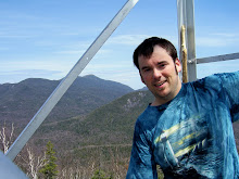
Our hiking party today consisted of five members of Hiking Mates. We started out of the Loj, and made our way up through Avalanche Pass and Lake, over to Lake Colden, up the back side of Colden and then down to Lake Arnold and back to the Loj. This was my first time to Avalanche Lake when it wasn't frozen and so therefore my first time having to use the hitch-up-matildas. That was a pretty cool experience and very scenic, although the path along the lake was as rugged as any stretch of "flat" trail there is; kinda reminds me of the bottom of the Scenic trail to Sawteeth Mt. We started out the hike with an overcast sky and a few misty drops, but were suppose to have clearing skies as the day went along. We took a quick little fuel-up break at the trail junction at Lake Colden to give us some energy to finish the assault of Mount Colden and it's a good thing! The trail from that direction is one of the more consistently steep trails in the 'dacks, and most of it was over rock slabs that had water running down them. Thankfully they weren't slick like that of Allen, and the footing was surprisingly good. Slowly but surely we all made our way up to the ladder, and attacked the last open rock scrambles to make it to the top. There was one tricky scramble were a couple of the hikers didn't think they could make it, and one trekking pole didn't, but with a little bit of courage all conquered the mountain and made it to the top! Once on top, and the cameras came out, I unknowingly started a summit photo ritual by deciding to pose on the top in the "Captain Morgan" pose. lol Also, just as we reached the summit the clouds finally broke and gave us some quite spectacular views towards the MacIntyre Range and over to Marcy. God's creation sure is amazing!


Our journey down from the summit went happily uneventful, past stinky Lake Arnold and down to Marcy Dam and back out. This was a nice change of pace from the last hike I did through the Santas. We also has the cool experience of meeting a man, his son and team that were in the process of attempting to set the world record for the fastest time summiting all 50 state high points, by doing it in 50 days! They bagged Marcy that day and were off for Mansfield and Katahdin next. Cool stuff!

The Santanonis, oh my! (6/16/10)

Ahh, the Santanonis...loved, er ok bemoaned by so many. The mud, the muck and the trailess wanderings! If the Santas weren't muddy and challenging enough on a good day, myself and my hiking partners for the day Lisa and Debbie, were treated to a forecast of rain for most of the day. :/ We knew it was going to be a long day, so we got the required early start and picked our way through the mud and water filled "maintained" trail back to the start of the Time Square herd path. We spotted it easily and for the most part had no trouble staying on the herd path. After being told and reading how steep and rugged the trail was up to Herald Square, I didn't find it all that bad in regards to what you would expect to find on a Adirondack high peak. When we got to Herald Square, we took the right to Panther Mountain and 15 or so minutes later we were on our first high peak of the day. We had a few minutes of decent view from the top, before the rain and clouds moved in and eliminated any more views for the rest of the day. We quickly made our way over to the famous Time Square and hunkered down under some trees and ate our lunch and donned our rain gear. From there we forged on to everyones favorite peak, Couchsachraga haha! Between the rain and the rain covered trees and brush we had to push through we definitely got a bit wet. After picking our way over the bog, and winding over false peak and false peak, we hit the half way point and the summit of Couch. When we made our way back to Time Square, we were all pretty miserable and tired but we met a man coming off Santa who I think was more of both than us, lol. Ahh good times. Well, onward we went, into the wind and the rain and the clouds that enveloped Santanoni Mt. When we reached the summit we snapped a couple of photos of each other, looking like wet rats and started out final stretch back to the car. Absolutely zero view to be had, so I suppose a return trip is in order at some point.
The most rugged and steep part of the whole climb was without a doubt the decent of the "new-old" trail, including the use of a twenty food rope that was needed to scale a rock face. Once we actually had the rope in hand it was actually quite enjoyable! As we reached the base of the mountain we had the only time during the day that we couldn't spot the trail, and that was because the trail actually led through the middle of a pond/bog that was flooded. With a little bit of guided bushwacking we soon picked it up and hit the maintained trail and began our soggy death march back to the car. I won't soon forget our 14 hour trek through the Santas, and not all of it was bad. :)

Algonquin and Iroquois (6/2/10)


I wasn't really sure what hike I was going to do up till several days before hike day, but as I was watching the weather forecast and saw that the weather was looking perfect for a hike, with clear skies and great views, I knew that I wanted to do a hike that would allow for some amazing views. Last October, when I had climbed Algonquin and Wright, it was in the midst of a snow storm and there were absolutely no views from the top of Algonquin. It seemed like the obvious choice, Algonquin and Iroquois! I posted the hike on Hiking Mates with only a few days notice, so I ended up doing this hike solo, which doesn't bother me in the least. I enjoy the company and entertainment of hiking with a group, but I also enjoy the peace and quietness of solo hiking. On my way up from the Loj, I ran into a number of parties of people also hiking Algonquin. No surprise there, as it is one of the most popular mountains in the 'dacks. I made great time up to the summit of Algonquin and was rewarded with some absolutely gorgeous views from on top! It's easy to see why this is one of the most hiked high peaks. While on top, I ran into Stu from VFTT and chatted with him for a few minutes, before being chased (well not really) by giant summit flies/bees over to Iroquois. The decent off the west side of Algonquin is one of my favorites in all the Adirondacks, the terrain is so cool and alpine! I forged my way through the herd path and over the bog, past Boundary Mt 1 and 2, and onto Iroquois. There were two tough rock scrambles that I had to scale to make it to the summit, but with a little time and caution I made it up both with no incidents and bagged my only new summit of the day. Wow, Iroquois is quite nice! It has an amazing view, but also a level of seclusion that it's big brother doesn't have. I enjoyed a good half hour or more on top, soaking up the view and the sun before packing up and heading back over to Algonquin. When I reached the summit of Al, I was greeted with a group of summit stewards and trainees, and two biologists. They were checking out the alpine flora as I said one last goodbye to the view and headed back down the trail.

I think overall this is one of my favorite hikes so far...great views, majestic mountains!

Dix and Hough (5/27/10)


Having just recently hiked the southern portion of the Dix Range, I wanted to finish it off and even though it meant a long, tough hike, it had to be done. I have done Dix Mountain before, but it had been a while, and it needed to be done to get to Hough, well more or less. Unfortunately for me, this happened to be the hottest day of the year to date! The temperatures as the day progressed moved into the low 90's and the sun was out in full force. Knowing that it was going to be a long, hot day, I had brought five bottles of fluids, close to a gallon combined.

My hike began with Tracy, whom I had first met, and hiked the lower half of the Dix Range with earlier that month, and another woman whom I had met for the first time at the park and ride that morning. We started out of the Rt 73, Round pond trailhead and within a half an hour of starting the woman who I hadn't hiked with before was gassed and ready to turn back. Tracy started the day feeling a bit sick from a lingering ailment and between the two of them, they decided to fall back and hike at a much slower pace and take trail as it came to them. With the two of them sticking together, I was determined to push on and bag my peaks that I had set out for; unfortunately I had a rather untimely mishap considering the current conditions that day. Two of my water bottle tops weren't secured all the way and I ended up losing almost 2 liters of water that I had started with. Through stubbornness or determination I pushed on to complete my goal for the day. The first 5 or so miles go pretty quick and easy, as I made my way back to the base of the slide on Dix. I have to say, that this hike especially and many more to come this summer were filled with more toads, frogs, grass snakes than I've ever seen before in the woods. Well, the Dix summit climb was just as I remembered it to be, extremely steep and rugged, for close to a mile. A bit whipped, and through rationing of my fluids, a bit thirsty, I reached the summit of Dix and was rewarded with a fantastic view on a clear day! After a quick lunch and some time to enjoy the view, I glanced over to Hough, and thought...do I really wanna trek all the way over there, just to have to turn around and come back the same way, on the two bottles of water/Gatorade that I had left? Well, the answer was no, but the choice was yes. I was determined to get it done! It was an adventure going over the Beckhorn and following the ridgeline over to Hough. Hough offered a great view of Dix from a perspective I hadn't seen before. The herd path was very narrow, but quite easy to follow. Thank goodness for gaiters! Re-climbing the Beckhorn involved a few rock scrambles that had me crawling and scooting/pulling myself up, but I managed, and on the summit of Dix, I drank the last of my water. I remember my mouth was so dry that I had absolutely no saliva and was feeling a bit of a headache. I new I was dehydrated and was seriously concerned about getting heat stroke. As I made my way down the bottom of the slide and the stream that forms off it, I decided to take the small risk of beaver fever and drink from the stream. The odds of me getting a bacteria were much lower than having some serious issues of dehydration or heat stroke. Once, fully re-hydrated I had renued vigor for the long trek back to the car. All said and done, it was one of the most tiring hikes I have done, due to the heat, lack of water, and long, difficult terrain. I am glad to have completed it and in the end, been no worse for the wear.

Thursday, June 3, 2010

Macomb, South Dix, East Dix (5/12/10)


So, my first "summer" high peak of the year started off totally by accident. I was planning on hiking Noonmark and Round Mt as a loop with the hiking group, but when no one signed up and I chanced on seeing someone post a comment about hiking Macomb on the same day, I jumped at the chance to upgrade my hike! I met up with Tracy and Bruce and we headed out of the Elk Lake trailhead, my first time to Elk Lake! The trail back to the starting point of the Macomb trailhead was pretty simple, basically just a walk in the woods. When we reached the turnoff point, just past Slide Brook we started the real hiking. The entire Dix range, with the exception of it's signature mountain, is trailess and quite remote and wild. I was excited and a little nervous about this hike, as it was my first time doing a slide hike. We got to the base of the Macomb slide around an hour after we took the turnoff onto the herd path. The Macomb slide is a bit unique from what I know in that it's made up primarily of loose rock, or scree. Being my first slide to climb I can't say how it compares to others, but I thought it was relatively easy to climb. It was steep in spots and the loose rocks made it tricky but my distain for heights never came into play. It was nice once we got to the top to take a breather and snap some photos on the famous boulder that overlooks the slide. We had an awesome day to go hiking! The weather was fairly sunny and maybe in the 70's. Once we left the top of the slide we had probably the steepest climb of the day, but over a kinda short stretch, to the summit of Macomb. The views from the top, while limited in range, did not disappoint in quality! Great views of Elk lake, and many of the high peaks. I even had the company of a little mountain sparrow while I ate lunch on the top. After a bite to eat, it was only I think 11:30am and we all still felt fairly full of energy and so after some discussion we decided to make the push to get the rest of the "lower" Dixes in. Since we were up on the ridgeline the effort would be moderate to minimal to get South and East Dix in. On the backside, or eastside of Macomb we encountered a little bit of ice and snow remnants, but very little and it posed no difficulty to our passage. Down into the col between Macomb and South Dix, then up the rocky scramble to South Dix. That part was pretty fun. We had some nice views from the open rocks and since there are zero views from the actual summit of South Dix we took some pictures and soaked it in. The ridge-line walk between all three mountains was interesting. I was a bit concerned from having read up on the Dix range and seeing everyone talk about how remote and the jumble of herd paths and that you should be ready with your compass and maps for the challenge of navigating them, but whether over the past few years the paths have become more established or I just have an eye for keeping a trail, we never had an issue finding and following the herd paths for the entire day. There were certainly some stretches of trail where it was so tight that you had to force your way through the cripplebrush and evergreens but the footpath itself was distinguishable. As we reached the third high peak summit of the day on East Dix, I was really impressed with the panoramic view it offered! All the way from Giant and Rocky Ridge, to the foothills in the South, South Dix and Macomb to the West, and Hough and Dix to the North, the views were awesome! Really a beautiful sight. I wish I had known exactly where the Great Slide was, as it would have been cool to gone and looked down on it, but I hadn't expected to be on East Dix that day and didn't read up on it. Well, our trip back was pleasantly uneventful. We made it back to the top of Macomb without a hitch. The toughest part of the hike might have been the descent down the slide. Having to pick your way down the steepness with loose rocks breaking way and sliding from under your feet definitely was a tedious and tiring process. We all made it down though safe and sound and although I think all of us were a bit sore and tired after 11 hours on the trail, we made it back to the cars happy and with a great sense of accomplishment! A wonderful hike through a great wilderness!

Wednesday, April 7, 2010

Phelps Mtn 2/18/10

I went into this winter wanted to get a couple high peaks done, to take some of the load off this coming summer. As it turned out, I ended up only getting this one. We left early in the morning and were on the trail by 9am. It was myself and HikingMates partner Jennifer. We started out of the Adirondack Loj, up past Marcy Dam and back the same way. The temps were pretty mild, in the twenties, but unfortunately the cloud cover was very low so our visibility was very poor for the hike, with no visibility at the top. The trails up to the Phelps trail were packed snow, with 2-3 inches of fresh powder on top. When we got to the Phelps trail we threw on our traction for the steeps and ice that we found on the last stretch. Overall, no issues with traction or on the trail. We encountered several parties on the way in, including a group that had over-nighted and was headed up to Algonquin, and then a handful of parties snowshoeing and skiing on the way back down. The black capped chickadees were out in force around Marcy Dam. We stopped for a picture and they came right down and were landing on my trekking poles, and even my hand! I'm sure they were hoping we had a snack for them, but no luck. Overall, I had a great time, but another hike this winter with no views or limited views on top. Oh well.

Big Slide 10/18/09

I decided to do the hike via the Brothers, and down Slide Brook to create a fun loop. My friend Dan and I had tried to do this hike last year, well not the loop but over the Brothers, and ran out of time to finish it. This time we left earlier in the morning and gave ourselves plenty of time to finish. When we left the Garden we were hiking in fall conditions: cool, leaves on the ground and some blue skies. As we made our way up past the second Brother we encountered snow and ice. We took a snack break on top of the first Brother and its great views entertained. There were still fall colors throughout the Great Range, but barely. One more week and they were probably gone. The hike from the second Brother up the the summit of Big Slide was over snow and ice, well mostly ice. The micro spikes we brought work like a charm. The last jaunt up to the summit was quite steep, with a couple ladders thrown in, but nothing technical, just had to do some scrambling. Once we made it to the top, I was amazed by the range of the views to be had. I think I counted 22 visible high peaks from the summit! I think this is currently my favorite vista from a high peak to date! The trail down the Slide Brook trail was much easier than the trail up over the Brothers and even easier from the Interior post back to the Garden. We passed a couple of leentos and jumped a two deer as we made our way back out. Overall a awesome hike, one that I won't mind doing again.